 Section map (enlarge image).
PENDLETON, 187 m., (1,070 alt., 6,620 pop.).
Points of Interest: Round Up Park, Pendleton Woolen Mills, Pioneer Park, Til Taylor Park, County Courthouse.
At Pendleton US 30 forms a junction with US 395, with which it unites westward to a junction at 188.2 m.
The EASTERN OREGON STATE HOSPITAL, (L) at 188.5 m., a modern institution, with buildings adequate for 1,325 patients.
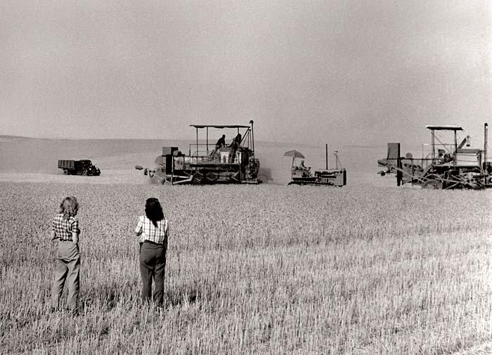
West of Pendleton is a section of the vast wheat region of the Inland Empire. In this area two million acres of wheatlands are under cultivation, and one might walk from Pendleton to The Dalles through growing grain. Early spring, tractors, drag plows, harrows, and drills cross rich brown fields; late summer and early fall, combines, drawn by tractors, mules, or horses, harvest the grain. Occasionally 32 horses are handled with one pair of reins as a combine travels around the golden foothills, cutting, threshing and sacking, exemplifying modern efficiency at its peak, in marked contrast with a scythe and cradle used by pioneers. These large scale operations directed by bronzed harvest crews, are as picturesque as the cattle drives of old. As in other semi arid portions of Oregon where wheat growing is a major industry, the practice of summer fallow is almost universal. Half the acreage is planted each year and the remaining fields are either allowed to lie idle until weeds are plowed under, or the acreage is plowed and harrowed at frequent intervals during summer to preserve moisture and to keep down weed growth. Tawny squares of ripened grain, alternating with dull blues, purples and blacks of the fallow fields, is the picture just before harvest.
 A car travels down the highway from Pilot Rock to Pendleton (g305). Enlarge image.
At 188.6 m. is a junction with a side road.
Left on this road, former route of US 30, to REITH, 2.7 m. (979 alt., 44 pop.), Pendleton Railroad division point. At 8.3 m. is HAPPY CANYON, an early-day settlement whose dance halls and gambling dens have been reproduced as a feature of the Pendleton Round-Up. ECHO, 23 m. (636 alt., 311 pop.), is a wool and wheat shipping point, near the site of old Fort Henrietta, an early day army post. At 24.4 m. is the junction with US 30 near Stanfield.
At 189.2 m. on US 30 is a junction with a gravel road.
Right here to the PENDLETON AIRPORT, 1.1 m. (1,500 alt.), the first regular stop of the eastbound United Airline planes from Portland to Salt Lake, Chicago, and New York. A branch route to Spokane makes connections here.
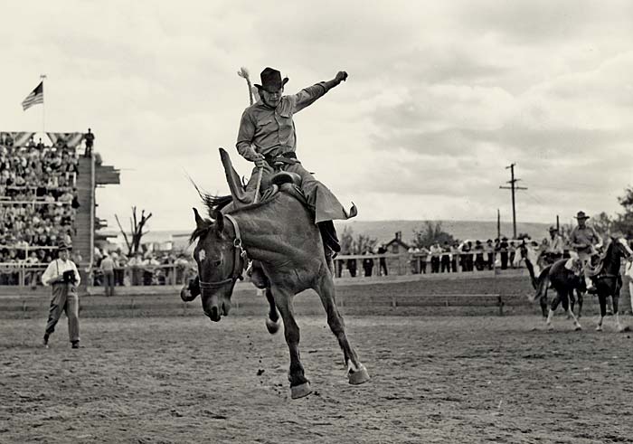
 Pendleton Roundup showing ride ’em cowboy (1320). Enlarge image.
At 194.5 m. is the approximate point where the Oregon Trail left the general course of what is now US 30, and crossed high plains to Willow Creek, Alkali Flats, went down Rock Creek Canyon, and crossed the John Day River to The Dalles.
STANFIELD, 210 m. (204 pop.), center of a great sheep raising country, was named for the Stanfield family, owners of a nearby ranch.
HERMISTON, 215.5 m. (459 alt., 608 pop.), a tree shaded oasis, with irrigation canals running through its streets is in the Umatilla Irrigation Project. Artificial waterways reclaimed from the desert the surrounding fields that produce crops of grain, vegetables and fruit and that stand out in startling contrast to the sagebrush. The town is the home of the Eastern Oregon Turkey Association, which ships thousands of birds annually, and it is well known for its desert honey. It was named for the Weir of Hermiston, written by Robert Louis Stevenson.
 Sheep near Meacham (165). Enlarge image.
Left from Hermiston on State 207 to BUTTER CREEK, 18.4 m., so named it is said, when volunteer soldiers during the Cayuse Indian War of 1848 appropriated some butter intended for the officers' mess. Another version of the story is that the soldiers on breaking camp left crocks of butter cooling in the stream. The creek courses through a broken country, hideout for a gang of cattle and horse thieves in the 1880s. They carried on their depredations until the stockmen organized vigilante committees. The first victim was hanged on a scaffold made of fence rails. To discourage cattle thieving, as well as prevent ownership confusion, raisers of stock filed with the county clerks small portions of leather on which were burned their identifying brands. Many of these leather brands are in the courthouses at Pendleton, Heppner, and Condon.
LEXINGTON, 38.1 m. (1,418 alt., 180 pop.), is an important wheat shipping point, named for the Massachusetts town. It began as a "wide place in the road" in 1885 and became a competitor with Heppner for the county seat of Morrow County. The townsite is on the homestead of William Penland for whom Penland Buttes to the north were named. At Lexington State 207 unites with State 74 and turns L. to CLARK RANCH, 46 m., where are the remains of an ancient stone sepulcher, one of several in this region. Found nearby are pictographs and artifacts. Anthropologists have surmised that these graves contain remains of a Mayan people, antedating the American Indians, who left a trail from the Columbia River to Central America.
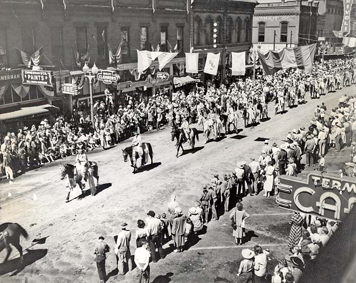
 A parade associated with the Pendleton Roundup (4321). Enlarge image.
HEPPNER, 47.4 m. (1,905 alt., 1,190 pop.), the seat and commercial center of Morrow County, is situated at the confluence of Hinton and Willow Creeks, on a level valley floor, sheltered between high dome like foothills. About 1858 cattlemen drove their herds into the region to forage. Finding an abundance of rye grass along the creek bottoms, they established cattle camps and from them grew the first settlements. Sheepmen followed, but their first experiments were unsuccessful and lent encouragement to the cattlemen's hope that the sheep business would fail. Today, however, sheep raising is a leading enterprise.
Heppner, the first permanent settlement in the region, was originally called Standsbury Flat, for George W. Standsbury, whose log cabin was for several years the only white man's dwelling within many miles. Heppner and Morrow established a store in 1872. When the need for a school was recognized in 1875, Henry Heppner, jumping on a cayuse, solicited the scattered settlers for funds. Later, at the suggestion of Standsbury, the town's name was changed. Heppner was completely razed by a flood, which swept down the Balm Fork into Willow Creek, following a cloudburst on Sunday afternoon, June 14, 1903. The wall of water, five feet high, drowned more than 200 persons, and damaged property to the amount of nearly 1,000,000.
Southwest of Heppner State 207 winds up SPRINGLE CANYON to SPRINGLE MILL SUMMIT, 51.9 m., from which are extended views of the Blue Mountains.
HARDMAN, 67.5 m. (3,590 alt., 120 pop.), once a center of commercial activity, is a village in a round depression of wheatlands that gives the illusion of great isolation. In the days of stage coaches, there were two villages in this vicinity. Yellow Dog stood on the Adams ranch, about a mile west of the town of Rawdog. There was great rivalry between the two for the stage depot and the post office, and when Rawdog finally won by strength of numbers, it was known for some time as Dogtown. Later it was called DairyvilIe, but the name was finally changed to Hardman for Dan Hardman, who had homesteaded the site.
Hardman is one of the few towns in Oregon where the old fashioned handworked pumps and town pump are in use.
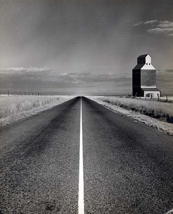
 A grain elevator near Stanfield (2207). Enlarge image.
South of Hardman the country levels into a wide plateau before dipping sharply into the Rock Creek Canyon, which marks the end of the wheat growing region and the beginning of the cattle and sheep ranges.
At 79.4 m. is a junction with a dirt road.
Left on this road 0.9 m. to the HARRY FRENCH RANCH, where fire opals of excellent quality have been found. The opal geodes lie in outcroppings from the surface to two feet in depth. In 1880 there was an "opal rush" to the district.
A boundary of the UMATILLA NATIONAL FOREST is crossed at 83.1 m.; the forest is noted for its magnificent stand of western yellow pine. Limited lumbering and the summer grazing of stock is permitted under Forest Service supervision.
At 89.3 m. is a junction with the Tamarack Mountain road; R. on this rough road 10 m. to TAMARACK MOUNTAIN, a splendid hunting ground where deer abound.
At FAIRVIEW FOREST CAMP, 91.5 m., named for the fine view of the Blue Mountains to the southeast, are the usual camping facilities. South of the camp the highway descends over a sharply winding road into the gorge of the John Day River, which cuts a great gash through the towering mountain ranges of eastern Oregon, to a junction with State 19, 100.3 m., at a point 3.1 miles east of SPRAY.
At 219 m. on US 30 are the UMATILLA COUNTY STATE GAME REFUGE, which shelters wild birds, especially migratory geese and ducks, and a GOVERNMENT IRRIGATION DAM. Below the dam, the Umatilla River's bed shows a curious rock formation similar to that at Celilo Falls.
At 221.7 m. is a junction with US 730.
Junction with US 730 to Portland, 192.7 m.
 A wheat harvest near Holdman (3040). Enlarge image.
West of the junction with US 730,
0 m., US 30 is called the Upper Columbia River Highway. It follows the south side of the river's magnificent gorge most of the way across the state.
UMATILLA, 0.9 m. (294 alt., 345 pop.), at the confluence of the Umatilla and Columbia Rivers, was founded in 1863 under the name of Umatilla Landing as a shipping point for the Powder River and Idaho mines during the rush to the gold fields. In June, 1863, its buildings numbered 53, thirteen of which had been erected in four days. The Oregonian for June 24, 1863, reported: "Very little regard is paid to the pretended title of the proprietor, Mr. Lurchin, as any one who wishes a lot just naturally jumps it." As a result the town boasted over 100 substantial buildings within six months after its founding. Twenty-five stores supplied the needs of citizens, packers, and stampeders, and two large hotels accommodated the traveling public. Wild eyed mule skinners and gents with gold in their pokes and a hankering for whiskey roared through the streets, and freight wagons, stage coaches, and pack trains clattered in from the dusty trails.
When Umatilla County was formed in 1862 Marshall Station, forty miles up the Umatilla River, was designated the county seat, but the seat was moved to Umatilla Landing in 1865, where it remained until 1868 when it was removed to Pendleton. In the years that followed Umatilla became the shipping point for large cargoes of grain from the eastern Oregon fields, but the Oregon Railway and Navigation line, constructed in the early eighties, diverted traffic and the town declined in importance as a port.