About the Exhibit

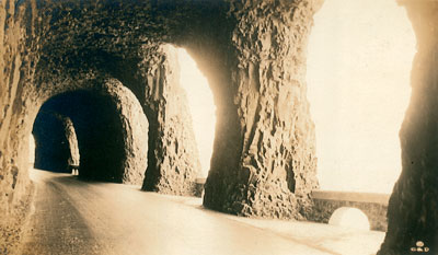
The iconic windows of Mitchell Point Tunnel west of Hood River. The tunnel was later destroyed after a road bypass. (Oregon State Archives, Private Donation Postcards)
This exhibit celebrates the centennial of the dedication of the Columbia River Highway in June 1916. It combines vintage photographs and postcards with modern scenic photographs to give the viewer a taste of the history and beauty of the highway and the surrounding Columbia River Gorge. Most of the photographs are from the Oregon State Archives holdings. Maps, diagrams and descriptive text add to the story of the highway.
About the Highway
The highway, later renamed the Historic Columbia River Highway, was built between 1913 and 1922. The historic route ran from Troutdale at the west end to The Dalles at the east end, about 75 miles in total. The oldest scenic highway in the country, its engineering excellence inspired the construction of other scenic roads nationwide. Among other recognitions, the highway has been designated as a National Historic Landmark.

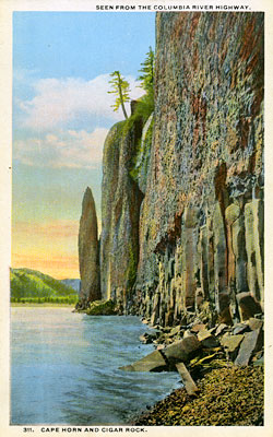
A vintage postcard shows Cape Horn and Cigar Rock across the river from the Historic Columbia River Highway. (Oregon State Archives, Private Donation Postcards)
Context: An Explosion of Car Ownership
During the 1910s, Henry Ford refined the assembly line for producing his soon to be ubiquitous Model T Ford. By 1913, a new Model T rolled off the line every three minutes and into a dealer showroom where it could be purchased for a few hundred dollars. The plummeting price soon put more middle and working class Americans in the driver’s seat.
The Push for Better Roads
Not surprisingly, these millions of new drivers demanded better paved roads and state and local governments responded to the clamor. Oregon created the State Highway Commission in 1913 to coordinate highway building policy statewide. There was much work to be done. At the time, most roads were dirt, leaving travelers choking in clouds of dust in the summer and wallowing in axle-deep mud in the winter.
The Ultimate Road Building Team
Entrepreneur Sam Hill wanted faster progress on the path to good roads. He dreamed of building a highway to rival the best scenic roads of Europe. And he saw the perfect route in the Columbia River Gorge, where the mighty river cuts through the Cascade Mountains, leaving a dramatic landscape punctuated by sweeping vistas, towering cliffs and lush waterfall canyons.
Hill enlisted his friend, engineer Sam Lancaster, to take the lead in what would become a county-state partnership backed by powerful Portland boosters. Lancaster didn’t shrink from the daunting challenge of creating a road worthy of the natural beauty of the Gorge. Using the most advanced engineering available, he routed the highway near the most spectacular waterfalls and viewpoints. Both Hill and Lancaster saw the highway as a showcase for the integration of human ingenuity and nature, an artful marvel of modern times.

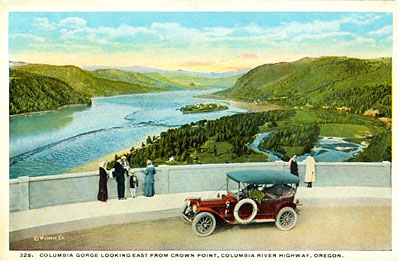
A vintage postcard shows tourists taking in the view from near Vista House at Crown Point. (Oregon State Archives, Private Donation Postcards)
A Brief Golden Age and Then a Bypass
The highway was completed in 1922 to rave reviews. Tourism expanded along with new hotels, stores and campgrounds. But the growing size and number of cars and trucks traveling the route quickly overwhelmed the highway. It could not be both a serene scenic road and a major east-west transportation corridor.
Plans soon developed to build a new water-level route that would be wider and straighter than the existing highway to accommodate traffic needs. In the process, some sections of the historic highway were abandoned beginning in the 1930s. Others were destroyed during the construction of the new highway. Eventually, Interstate 84 was built to handle the demands of modern car and truck traffic.
Renewed Interest and Restoration
While the route can never be fully returned to its glory of the 1920s, during the last two decades, the state has restored several significant sections of the historic highway, including some for pedestrian and bicycle traffic only. Further improvements are underway.
Explore the Exhibit
Learn more about this engineering gem, also known as the “King of Roads,” in the exhibit that follows...
Next: Current and Vintage Maps >