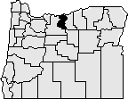
Sherman County was created in 1889 out of the northeast corner of Wasco County. It was named for General William Techumseh Sherman of Civil War fame. Sherman County is located in north central Oregon and is bounded by the Columbia River on the north, the John Day River and Gilliam County on the east, and the Deschutes River, Buck Hollow, and Wasco County on the west and south. The only change made to the county's borders occurred in 1891 when the Legislative Assembly moved the county line 18 miles farther south.
Sherman County contains 831 square miles. The town of Wasco was designated the county seat by the Legislative Assembly although the selection was contested between Wasco and Moro. Moro benefited from the addition to the southern part of the county of a portion of Wasco County and was the eventual winner of a series of elections to select a county seat.
The county contracted in 1892 to construct a building and vault on the main street of Moro for use as an interim courthouse. A permanent courthouse was built in 1899 on a hill overlooking the town and is still in use today. That courthouse received a major renovation in 2018, including a new tower. A new adjacent building, called the courthouse addition, was also constructed in 2018. This building houses the circuit court, justice court, sheriff and other justice-related offices.
A county court has governed Sherman County since its creation. Administrative functions for Sherman County continue to be the responsibility of the county court consisting of the county judge and two commissioners. Other elected officials are the assessor, county clerk, district attorney, sheriff, and treasurer.
The population of the county has remained remarkably constant, in 1890 there were 1,792 residents and in 2018 there were 1,785 residents, a rise from 1,765 residents in 2010.
Sherman County is an agricultural county. It has a larger percentage of its 831 square miles under cultivation than any county in Oregon. Its farms are devoted to growing wheat and barley. Cattle raising also contributes to the county's economy as does recreation on the rivers bordering the county. In recent years, electricity generating wind turbines have sprouted in large wind farms in several areas such as east of Wasco. The income, both to landowners and to the county, has been a welcome economic boost. The Oregon Raceway Park, just outside of Grass Valley, also has added to the county economy.