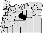
Crook County was established
Oct.
24, 1882. It was created from the southern part of Wasco County and named after U.S. Army Major-General George Crook, a hero of the Snake Indian Wars.
Crook County is in the geographic center of Oregon. It was reduced from its original size of 8,600 square miles to 2,991 square miles by the creation of Jefferson County in 1914 and Deschutes County in 1916. The current boundaries were established in 1927. Crook County is bounded by Jefferson and Wheeler Counties to the north, Grant and Harney Counties to the east, and Deschutes County to the south and west.
The area developed slowly
because the Cascade Mountains formed an imposing barrier to travel. But the discovery of the Santiam Pass in 1859 and the development of the Santiam Wagon Road helped spur the settlement of the Crook County area. Finally, in 1862 a supply train with cattle crossed the Scott Trail. It was
the first group of non-natives to spend the winter in this part of central Oregon.
In 1882 the Legislative Assembly established Prineville as the county seat. The voters confirmed the choice of Prineville, the only incorporated town in the county, in the 1884 general election. Prineville was named in honor of the town's first merchant, Barney Prine.
The first courthouse was a one story wooden structure at the corner of West 5th and Main Streets. In 1885 a two story wooden structure was built for $5,474. By 1905 this building was considered unsafe to store the county's records, and a $16,526 bid was accepted to erect a new, brick and stone courthouse. The building was completed in 1909, at a cost $48,590, and remodeled in the early 1990s with structural enhancements.
Early officials of the government
were a county judge, two county commissioners, assessor, clerk, coroner, school superintendent, surveyor, treasurer, and sheriff. By 1993 the last of the county judge's limited judicial powers were transferred to the circuit court. The full-time county judge now heads the county court and functions as county administrator.
The first census in 1890 showed a population of 3,244 excluding Native Americans. The 2013 census total of 20,690 showed a slight decrease of 1.4%
from the 2010 census. Still, the fast pace of growth in the nearby Bend-Redmond area will likely play a role in the long-term trend of a rising Crook County population.
The economy of the county is generally based on agriculture and forestry. Agriculture is supported by the development of irrigation districts, which permits the raising of hay, grain, mint, potatoes
and seed. Range and forest lands allow grazing for a sizable livestock industry. The Ochoco National Forest's stand of ponderosa pine is the main source of lumber. Tourism, recreation, and high-tech computer server farms help
strengthen the economy.
Crook County Records Inventory >